|
|
Post by sandipaws on Jun 19, 2021 20:38:16 GMT -5
Kailua-Kona, Big Island of Hawaii
|
|
|
|
Post by sandipaws on Jun 23, 2021 15:38:00 GMT -5
Kilohana Square, Oahu
|
|
|
|
Post by sandipaws on Jun 23, 2021 15:39:10 GMT -5
Kualapuu, Molokai
|
|
|
|
Post by sandipaws on Jun 26, 2021 21:53:08 GMT -5
Kaulaʻināiwi Island, Big Island of Hawaii
Kaulaʻināiwi Island is an island in Hawaii County, Hawaii.
The Mayor is William "Billy" Sanders, a descendant of Captain Cooke and a lifelong resident of the islands.

|
|
|
|
Post by sandipaws on Jun 28, 2021 15:28:44 GMT -5
Kumukumu, Kauai
|
|
|
|
Post by sandipaws on Jun 30, 2021 15:09:59 GMT -5
Kaanapali, Maui
|
|
|
|
Post by sandipaws on Jul 1, 2021 16:47:42 GMT -5
Kiekie, Niʻihau
Kiekie is a populated place located on the island of Niʻihau in Kauai County at latitude 21.886 and longitude -160.22.
Niʻihau
Nickname: The Forbidden Isle Aerial view of Niʻihau looking southwestward from the northeast Aerial view of Niʻihau looking southwestward from the northeast
Niʻihau, anglicized as Niihau, is the westernmost main and seventh largest inhabited island in Hawaii.
It is 17.5 miles southwest of Kauaʻi across the Kaulakahi Channel. Its area is 69.5 square miles.
Several intermittent playa lakes provide wetland habitats for the Hawaiian coot, the Hawaiian stilt, and the Hawaiian duck. The island is designated as critical habitat for Brighamia insignis, an endemic and endangered species of Hawaiian lobelioid.
The United States Census Bureau defines Niʻihau and the neighboring island and State Seabird Sanctuary of Lehua as Census Tract 410 of Kauai County, Hawaii. Its 2000 census population was 160; Its 2010 census population was 170.
|
|
|
|
Post by sandipaws on Jul 2, 2021 19:08:03 GMT -5
Kāneʻohe Bay, Oahu
Kāneʻohe Bay is the largest sheltered body of water in the main Hawaiian Islands. This reef-dominated embayment constitutes a significant scenic and recreational feature along the northeast coast of the Island of Oʻahu.

Kāneʻohe Bay on a calm morning viewed from the Kokokahi YWCA at the south end of the bay.
|
|
|
|
Post by sandipaws on Jul 3, 2021 21:05:20 GMT -5
Keck Observatory, Island of Hawaii
  W. M. Keck Observatory is part of the Maunakea Observatories, a collaboration of nonprofit independent institutions with telescopes located on Maunakea on the island of Hawaii. W. M. Keck Observatory is part of the Maunakea Observatories, a collaboration of nonprofit independent institutions with telescopes located on Maunakea on the island of Hawaii.
From Hawaii’s Maunakea, astronomers around the world use W. M. Keck Observatory to observe the universe with unprecedented power and precision.
The twin Keck Observatory telescopes are the world’s most scientifically productive optical and infrared telescopes. Each telescope weighs 300 tons and operates with nanometer precision. The telescopes’ primary mirrors are 10-meters in diameter and are each composed of 36 hexagonal segments that work in concert as a single piece of reflective glass.
In the middle of the Pacific Ocean, Hawaii Island is surrounded by thousands of miles of thermally stable seas. The 13,796-foot Maunakea summit has no nearby mountain ranges to roil the upper atmosphere. Few city lights pollute Hawaiian night skies, and for most of the year, the atmosphere above Maunakea is clear, calm and dry -— offering the best seeing on Earth.
|
|
|
|
Post by sandipaws on Jul 6, 2021 18:48:47 GMT -5
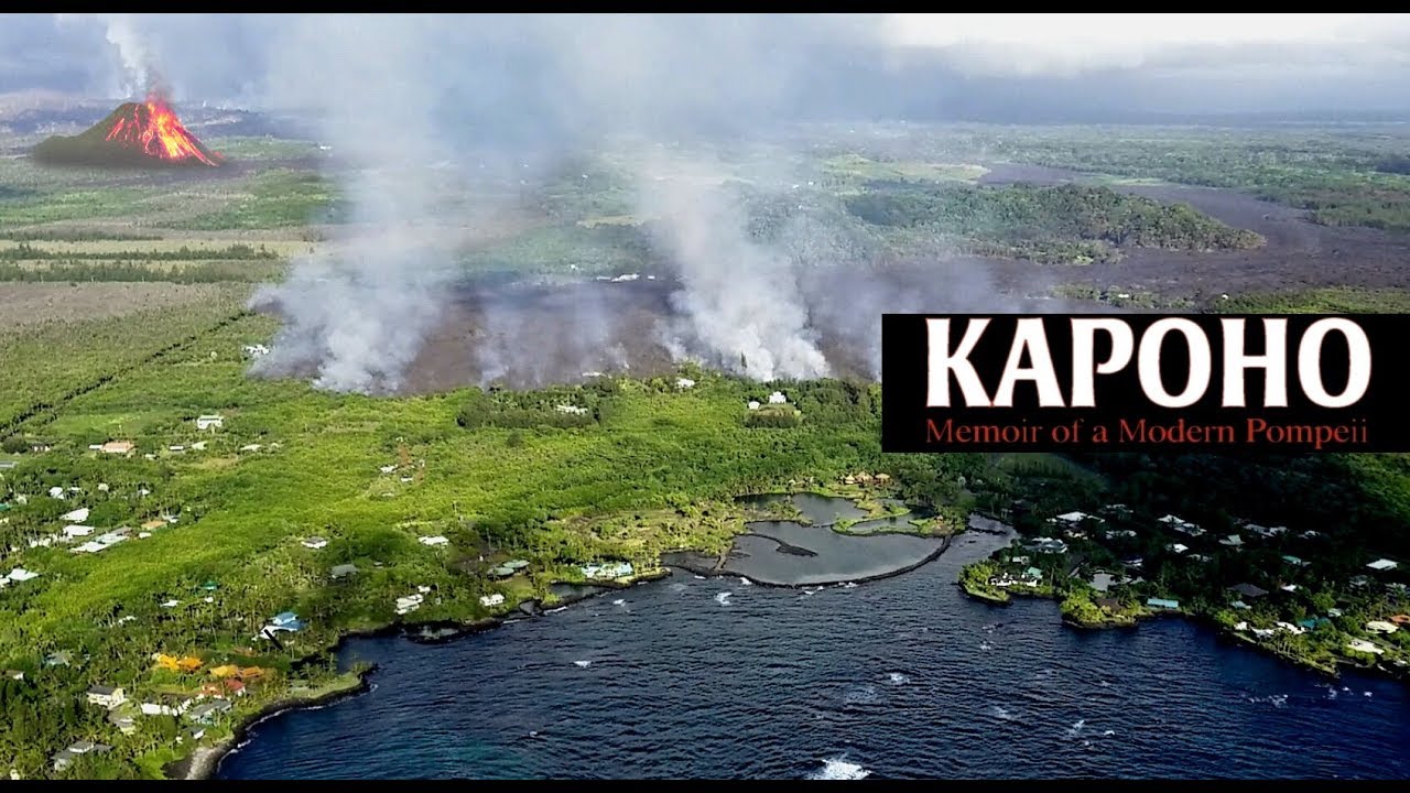
Kapoho, Big Island of Hawaii
Kapoho, Hawaii, is a now-uninhabited unincorporated area in Puna district, Hawaii County, Hawaii, located near the eastern tip of the island of Hawaii, in the easternmost end of the graben overlying Kīlauea's east rift zone. Originally destroyed by an eruption of Kīlauea in 1960, it was rebuilt as a community of private homes and vacation rentals. In the eruption that began in May 2018, the town was largely destroyed by lava by early June, and the bay filled in as the lava flow extended out into the ocean.
Before
 
After
|
|
|
|
Post by sandipaws on Jul 6, 2021 19:20:46 GMT -5
Kaho'olawe
 Kahoʻolawe is the smallest of the eight main volcanic islands in the Hawaiian Islands. Kahoʻolawe is the smallest of the eight main volcanic islands in the Hawaiian Islands.
Kahoʻolawe is located about seven miles southwest of Maui and also southeast of Lānaʻi, and it is 11 miles long by 6 miles wide, with a total land area of 44.97 square miles.
|
|
|
|
Post by sandipaws on Jul 9, 2021 19:22:28 GMT -5
 Kure Atoll Kure Atoll
Related town: Nenele‘a (historical)
State Capital: Honolulu, Hawaii
Kure Atoll (/ˈkʊəriː/; Hawaiian: Mokupāpapa) or Ocean Island is an atoll in the Pacific Ocean 48 nautical miles (55 mi) west-northwest of Midway Atoll in the Northwestern Hawaiian Islands. A coral ring six miles across encloses a lagoon several meters deep. The only land of significant size is called Green Island and is a habitat for hundreds of thousands of seabirds. A short, unused and unmaintained runway and a portion of one building, both from a former United States Coast Guard LORAN station, are located on the island.
Politically, it is part of Hawaii, although separated from the rest of the state by Midway, which is a separate unorganized territory. Green Island, in addition to being the nesting grounds of tens of thousands of seabirds, has recorded several vagrant terrestrial birds including snow bunting, eyebrowed thrush, brambling, olive-backed pipit, black kite, Steller's sea eagle and Chinese sparrowhawk.
It is currently managed as a Wildlife Bird Sanctuary by the State of Hawaii's Department of Land and Natural Resource--Division of Forestry and Wildlife as one of the co-trustees of Papahānaumokuākea Marine National Monument with support from Kure Atoll Conservancy.
Kure is inhabited by small crews of usually four people who collect trash which washes up and research the wildlife. Kure was discovered in the 19th century and was a common site of shipwrecks, and then in the late 20th century was home to a radio base that supported location finding. In the 21st century it is mostly a nature reserve.
en.wikipedia.org/wiki/Kure_Atoll#:~:text=Before%20the%20mid-19th%20century%2C%20Kure%20Atoll%20was%20visited,The%20old%20name%20for%20island%20was%20Ocean%20Island |
|
|
|
Post by sandipaws on Jul 10, 2021 22:10:22 GMT -5
Kea'au, Big Island   Kea'au, formerly known as Ola'a, is located in the eastern part of the Big Island in the Puna District. The town is surrounded by an Ohia forest, and nearby are black-sand beaches and a plethora of botanical gardens. The town's 20-hectar greenhouse Pacific Floral Exchange and Hi'iaka Healing Herb Garden are the most visited. Kea'au, formerly known as Ola'a, is located in the eastern part of the Big Island in the Puna District. The town is surrounded by an Ohia forest, and nearby are black-sand beaches and a plethora of botanical gardens. The town's 20-hectar greenhouse Pacific Floral Exchange and Hi'iaka Healing Herb Garden are the most visited.
Kea'au was once connected to the neighboring towns of Hilo and Pahoa by the Hawaiian Consolidated Railway. The railroad was used to transport agricultural products and passengers in the 19th century until it was destroyed by the 1946 tsunami.
Today, the town is a bedroom community for Hilo's workforce. On weekdays in the mornings and late afternoons, the traffic is bad in this area as everybody commutes to and from work in Hilo.
Kea'au Overview
Bedroom community three miles south of Hilo. Two attractions are the Pacific Floral Exchange and Hi'iaka Healing Herb GardenPopulation: 2,253 (2010 Census)
|
|
|
|
Post by sandipaws on Jul 18, 2021 19:34:49 GMT -5
Kipu Falls
Kipu Falls Rope Swing. My favorite place to jump! Yes! Kauai!! #kipu falls, #kauai, #hawaii  Kipu Falls is a fairly small waterfall just outside of Lihue, in East Kauai, Hawaii. The falls, fed by the Hule'ia Stream on its way to the Nawiliwili Bay, is a popular tourist attraction in the island because of its beauty and accessibility. Kipu Falls is a fairly small waterfall just outside of Lihue, in East Kauai, Hawaii. The falls, fed by the Hule'ia Stream on its way to the Nawiliwili Bay, is a popular tourist attraction in the island because of its beauty and accessibility.
The falls are surrounded by 20-foot rock walls lush with vegetation and features an inviting pool of crystal-clear water below. It is a favorite swimming hole among locals who have tied ropes to nearby trees which are used to swing and jump into the inviting pool.
|
|
|
|
Post by sandipaws on Jul 22, 2021 20:05:15 GMT -5
Kawainui Marsh Restoration Project
Kawainui Marsh or Kawainui Fishpond is a wetland and former fishpond in Kailua, Hawaiʻi. It is the largest remaining wetland and the largest ancient freshwater fishpond in Hawaiʻi, and a designated Ramsar Convention wetland.
Kawainui is a habitat for native Hawaiian water birds including the four endangered bird species ae’o, ʻalae ʻula, ʻalae kea, and koloa, for which the United States Fish and Wildlife Service identified it as a "primary habitat". It is also used by migratory birds.  
|
|